les Estables - le Mezenc aller /retour

Evelyne et Francois
User
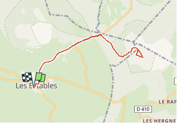

Length
9.2 km

Max alt
1740 m

Uphill gradient
404 m
Km-Effort
14.5 km

Min alt
1335 m

Downhill gradient
404 m
Boucle
Yes
Creation date :
2021-01-26 11:00:45.509
Updated on :
2021-01-26 11:02:55.126
2h30
Difficulty : Very easy

FREE GPS app for hiking
 SityTrail
IGN / Geographical institutes
SityTrail Plus
The world is yours!
About
Trail On foot of 9.2 km to be discovered at Auvergne-Rhône-Alpes, Haute-Loire, Les Estables. This trail is proposed by Evelyne et Francois.
Positioning
Country:
France
Region :
Auvergne-Rhône-Alpes
Department/Province :
Haute-Loire
Municipality :
Les Estables
Location:
Unknown
Start:(Dec)
Start:(UTM)
591191 ; 4972794 (31T) N.
Comments